Watching Our Watersheds now available!
By Julie Kahrnoff
A powerful, interactive and free educational tool is now available for educators everywhere, and for visitors to the Don Edwards San Francisco Bay National Wildlife Refuge. If you’re curious about the creeks, baylands, and urban drainage networks, or would like to teach your students about the local watershed, this computer program using satellite technology may be just the tool.
Watching Our Watersheds (WOW) is a project to map the creeks, urban drainage networks, watersheds, baylands, and points of interest in Santa Clara Valley. Anyone can now download these maps and view them interactively through Google Earth.
These maps have many layers including past landscapes of the San Francisco Bay. With WOW you can compare the waterways and habitats of the late 1800s to the present-day landscape. Within the maps exist points of interest such as diaries of Forty Niners who stopped in San José on their way to and from the gold mines, lists of birds and plants from early botanists and ornithologists, and some of the earliest landscape photography taken in the state. Archives were searched for every photograph, map, and manuscript revealing aspects of the Santa Clara Valley’s former ecological landscape. Each map comes with a User’s Guide to navigating in Google Earth and answers to FAQs about the WOW project and the individual layers in the map. The maps cover western, central and southern Santa Clara County.
This interactive program allows educators to show pathways of urban runoff and teach about watershed health. Currently, the Living Wetlands program uses WOW in the classroom to locate the student’s school to show what watershed they are in, the closest water body to the school, and the type of historical habitat they are in. It is used to teach what urban runoff is and ways to reduce it. Intern Diane Luu observed that when WOW was presented in the classroom, &quo;the kid’s eyes lit up just being able to see an aerial view of their school. It really tied in everything the students had been learning about watersheds and helped create the connection of personal responsibility&quo;. Students and teachers can add their own points of interest and personalize their own watershed map.
Go to the Santa Clara Valley Water District Website and begin using this great resource!
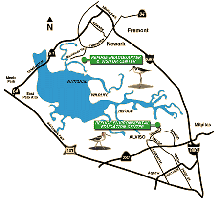
You can also visit the new computer station at the Environmental Education Center in Alviso. With touch screen capabilities you can locate your home, find your local wastewater treatment plant, or follow the storm drain in front of your school. The kiosk also offers information on storm water pollution prevention and history of the bay. The kiosk even features endangered species and illustrate where certain endemic and native species can be found.
The watershed maps were prepared by Fugro Consultants, Inc. with the San Francisco Estuary Institute, the Oakland Museum of California, CLEAN South Bay, and many other collaborators and colleagues. Major funding was provided by the San Francisco Bay Wildlife Society, along with Santa Clara Valley Water District, Committee for Green Foothills, City of Palo Alto, Santa Clara County Creeks Coalition, and Santa Clara Valley Urban Runoff Pollution Prevention Program.
For western Alameda County watershed maps in the Google Earth format, check out the Oakland Museum of California’s web site.
Upcoming Activities
-
Sat, Jan 18 2025 - 9:00 am to 11:00 am
-
Sun, Jan 19 2025 - 9:00 am to 12:00 pm
Tide Rising
Tide Rising is a quarterly, digital newsletter published by the San Francisco Bay Wildlife Society with information about the San Francisco Bay National Wildlife Refuge Complex and its seven Refuges.